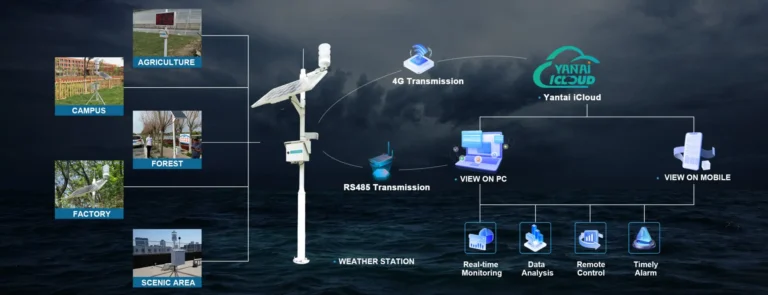
소개
Visibility plays a critical role in transportation safety, weather forecasting, aviation operations, and environmental monitoring. Reduced visibility caused by fog, haze, dust, smoke, or heavy precipitation can significantly affect road traffic, airport operations, maritime navigation, and industrial activities. To ensure accurate and continuous monitoring, modern weather and environmental systems increasingly rely on visibility sensors to provide real-time atmospheric visibility data and support timely decision-making.
How does a visibility sensor work? A visibility sensor measures how airborne particles interact with light by analyzing the scattering or absorption of a projected light beam. Using optical measurement technologies such as forward scattering, the sensor calculates the Meteorological Optical Range (MOR), the international standard used to quantify visibility distance. Today, visibility sensors are widely used in weather stations, highways, airports, ports, mining sites, and smart transportation systems, helping organizations improve safety, optimize operations, and respond more effectively to changing environmental conditions.
What Is a Visibility Sensor?
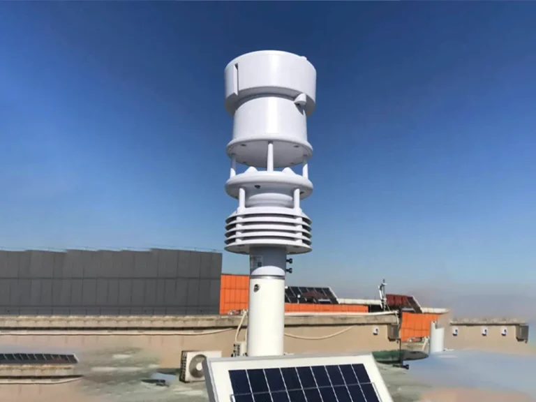
A visibility sensor, also known as an 대기 가시성 센서 or meteorological visibility sensor, is an optical instrument used to measure the distance at which objects or light sources can be clearly detected in the atmosphere. By analyzing how airborne particles such as fog, haze, dust, and smoke scatter light, the sensor calculates visibility in real time and provides reliable data for weather monitoring and transportation safety. Modern visibility sensors can typically measure visibility ranges from 10 m to 20 km, making them widely used in 기상 관측소, airports, highways, ports, and industrial monitoring systems.
What Does a Visibility Sensor Measure?
A visibility sensor measures the clarity of the atmosphere by determining how far a person or object can be seen under current environmental conditions. It primarily calculates the meteorological optical range (MOR), an internationally recognized standard that represents the maximum distance at which a light source can be detected. By analyzing the effect of fog, haze, dust, smoke, rain, and other airborne particles on light transmission, a visibility sensor provides accurate real-time visibility data for weather monitoring, aviation, transportation, and environmental applications.
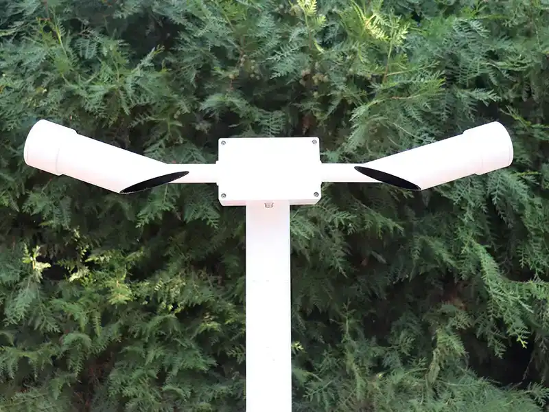
Structure of a Visibility Sensor
- Transmitter: Emits an infrared beam of a specific wavelength (typically 850 nm).
- Receiver: Captures the light signal scattered by airborne particles.
- Microprocessor controller/junction box: Calculates the relationship between scattering intensity and extinction coefficient in real time.
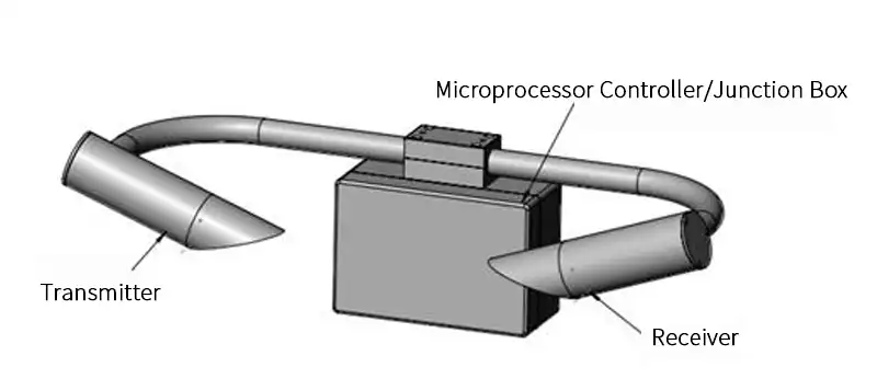
⚠️ Note: There is an indicator light on the bottom of the controller box that can be used to check whether the visibility sensor is working properly.
Visibility Sensor Features and Advantages
- Specifically designed for highway monitoring, offering excellent value for money.
- Compact and lightweight, making it easy to install and transport.
- No on-site calibration required; simply install the visibility sensor, set up the accompanying software, and it’s ready to use.
- Waterproof design with a rugged housing, suitable for use in remote areas.
- The instrument features built-in data management capabilities, storing real-time visibility readings every minute in its internal memory. Data is stored and retrieved in units of minutes by date and time and can be downloaded and exported via the software; the instrument can store one month’s worth of data, which is retained even during power outages.
⚠️ Special installation considerations:
Install within the optimal height range of 1.5–3 meters above ground level; avoid obstructions such as trees and billboards; maintain a minimum interference distance from other meteorological sensors.
Why Is Visibility Monitoring Important?
Improving Road Safety
Real-time visibility monitoring helps traffic authorities detect fog, haze, and other low-visibility conditions early, reducing accident risks and enabling timely traffic management measures.
Supporting Airport Operations
Accurate visibility data is essential for safe aircraft takeoff, landing, and ground operations, helping airports comply with aviation safety standards and minimize weather-related disruptions.
Enhancing Maritime Navigation
Visibility sensors provide continuous monitoring of fog and atmospheric conditions in ports and waterways, improving navigation safety and reducing the risk of maritime accidents.
Assisting Weather Forecasting
By measuring changes in atmospheric visibility, meteorologists can better track fog formation, haze events, and severe weather conditions to improve forecast accuracy.
Protecting Industrial Facilities
Industrial sites such as power plants, mines, and chemical facilities use visibility monitoring to assess environmental conditions, enhance operational safety, and support regulatory compliance.

How Does a Visibility Sensor Work?
Based on optical principles, visibility values are calculated by detecting the scattering and attenuation of light in the atmosphere. The main types include transmission-based, forward-scattering (the most common), and back-scattering methods. The core logic of all these methods is to infer the concentration of suspended particulate matter in the atmosphere based on changes in light signals, thereby determining visibility.
Core operational logic
Visibility is essentially the degree to which light is attenuated by suspended particles (fog droplets, smoke, dust, etc.) in the atmosphere; the more particles there are, the lower the visibility. Visibility sensors use optical methods to convert this attenuation into a quantifiable electrical signal, and the visibility value is ultimately calculated using a standard formula.
Currently, the industry-standard calculation method follows Koschmieder’s law, which is expressed by the formula: MOR (Km) = 2.996 / σ, where MOR is the meteorological optical range (i.e., visibility) and σ is the atmospheric extinction coefficient, as measured by a sensor.
Mainstream Technology Types and Principles
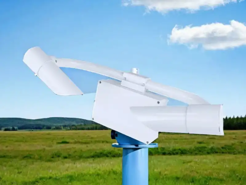
1. Forward Scattering Type (Currently the Most Widely Used)
Forward scatter visibility sensor for road, this is the mainstream type currently used on highways and at standard weather stations. Visibility sensor working principle:
- The sensor integrates a transmitter and a receiver, which are positioned at an angle of 30°–45° to each other;
- The transmitter emits a modulated beam of a specific wavelength (typically near-infrared light at 850 nm–880 nm to minimize interference from sunlight);
- When the beam encounters particulate matter in the air, it undergoes forward scattering (the scattering direction forms a small angle with the original beam direction), and the receiver specifically detects the intensity of the scattered light within the measurement area;
- The higher the particulate matter concentration (the lower the visibility), the stronger the scattered light intensity. The microprocessor calculates the extinction coefficient based on a calibrated relationship and ultimately converts this into a visibility value.
장점: Compact design, no need for a long baseline, easy to install, cost-effective, and simple to maintain; it is currently the mainstream choice on the market, 90% of the visibility sensors on the market are of this type.
2. Transmission type (highest accuracy; commonly used at airports)
This is the reference method recognized by the World Meteorological Organization, and its principle is closer to the original definition of visibility:
- The transmitter and receiver are installed at either end of a fixed baseline ranging from several dozen meters to over 100 meters;
- The transmitter emits a stable beam of light toward the receiver, and the receiver measures the light intensity after it has traveled that distance;
- The atmospheric extinction coefficient is calculated using the Beer-Lambert law, and visibility is then determined using the MOR formula.
장점: Highest accuracy and stable measurement results;
Disadvantages: Requires a long baseline, has stringent site requirements, involves complex installation and commissioning, and is costly; it is primarily used in locations with extremely high accuracy requirements, such as airport runways.
3. Backscatter Type (Compact and Simple, Portable for Use in Vehicles)
The transmitter emits a beam of light and measures the backscattered light signal, which returns along nearly the same path (typically at a very small angle to the transmitted beam or coaxially). Visibility is calculated based on the empirical relationship between the backscatter intensity and the total extinction coefficient.
장점:
① It features the most compact design, typically a single-ended configuration, with all optical components integrated into a single probe, making installation extremely convenient.
② It is particularly suitable for installation on mobile platforms (such as vehicles and ships) or in locations with limited space.
Disadvantages: The margin of error is relatively large, so it is primarily used for simple early warnings and is not intended for professional meteorological measurements.
4. LiDAR Visibility Meter (Fog-Measuring LiDAR)
Measurement Principle: This is an active remote sensing device. It emits laser pulses into the atmosphere and receives signals scattered back by aerosols and molecules in the atmosphere (including Mie scattering and Raman scattering). By analyzing the attenuation of the echo signals as a function of distance, the vertical or horizontal spatial distribution of the extinction coefficient can be derived, thereby providing slant-range visibility or profilometric information.
장점:
① Provides spatial distribution information, not just single-point data. For airports, it can detect fog layer height and evolution trends.
② Long detection range (from several kilometers to over ten kilometers).
Disadvantages:
① The equipment is extremely expensive, and operation and maintenance are complex.
② Data processing algorithms are complex.
③ Primarily used in high-end scientific research and specific early-warning applications (such as large airports and meteorological research).
5. Video Visibility Meter (Digital Videography Method)
Use a high-definition camera to capture images of stationary targets at a known distance, size, and brightness (such as a black target, a mountain, or a building). Employ image processing techniques to analyze the contrast attenuation between the target and the background sky and to calculate visibility based on Koch-Schmiedt’s law.
장점:
① Intuitive; the measurement principle most closely resembles human visual observation.
② Can utilize existing surveillance camera networks, potentially resulting in lower hardware costs.
③ Capable of simultaneously capturing real-time weather images over a wide area.
Disadvantages:
① Accuracy is greatly affected by lighting conditions (day/night, backlighting), target characteristics, and image quality; auxiliary lighting is required for nighttime measurements.
② The algorithm is complex, and its stability is highly susceptible to weather and environmental conditions.
③ Currently, these methods are mostly used for auxiliary or qualitative observations and are not suitable as standard instruments for high-precision quantitative measurements.
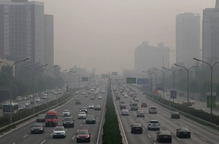
The Relationship Between Visibility Sensors and Air Pollution Monitoring
Reduced visibility is typically directly correlated with the concentration of particulate matter in the air: According to actual measurement data, when visibility is 14.8 kilometers, the particulate matter concentration is approximately 100 micrograms per cubic meter; when visibility is 2.8 kilometers, the concentration is approximately 300 micrograms per cubic meter. Therefore, data from visibility sensors can serve as a reference indicator for assessing air quality and assist environmental protection agencies in monitoring air pollution levels.
Specifications for Visibility Meters
| 매개변수 | 값 |
|---|---|
| Power Specification | DC12V |
| 측정 범위 | 5-10000m; 5-30000m; 5-80000m |
| 정확성 | ±2% (≤1000m); ±10% (≥1000m) |
| 해상도 | 1m |
| Output Interval | 60s |
| Interface | RS485; RS232 |
| Light Source Wavelength | 940nm |
| Forward Scattering Measurement Angle | 33 degrees |
| 신뢰성 | Mean Time Between Failures (MTBF) ≥ 5000 hours |
| 치수 | 720mm x 370mm x 165mm |
| 전력 소비량 | ≤10W |
| 무게 | ≤15kg |
| 작동 온도 | -45℃ ~ +50℃ |
| 작동 습도 | 0~100%RH |
| 대기압 | ≥650hPa |
| 데이터 업데이트 빈도 | 1/min |
| Mean Time Between Failures (MTBF) | ≥15000h |
Visibility Sensor Measurement Range and Accuracy
The measurement range and accuracy of a 가시성 센서 are critical factors when selecting a solution for weather monitoring, transportation safety, and industrial applications. Modern visibility sensors use advanced optical technology to provide reliable visibility data across a wide range of environmental conditions, from dense fog to clear skies. Choosing the appropriate range and accuracy level ensures the sensor can meet the operational requirements of airports, highways, ports, and meteorological stations.
Typical Measurement Ranges
Different applications require different visibility monitoring capabilities. Most commercial visibility sensors offer measurement ranges between 10 m and 20 km, while high-end models designed for aviation and meteorological networks can exceed 30 km.
- Highways and Tunnels: 10 m–2 km
- Airports and Runways: 10 m–10 km
- Weather Stations: 10 m–20 km
- Ports and Maritime Navigation: 10 m–15 km
- Industrial Facilities and Mining Sites: 10 m–5 km
Typical Accuracy Specifications
Visibility sensor accuracy depends on the measurement technology, environmental conditions, and calibration quality. High-performance forward scatter visibility sensors typically achieve an accuracy of ±10% within the measured range, providing dependable visibility data for safety-critical operations.
Key factors affecting accuracy include:
- Fog density and particle size
- Heavy rain or snowfall
- Dust and smoke concentration
- Optical window cleanliness
- Installation location and height
- Regular calibration and maintenance
For applications such as airport operations, intelligent transportation systems, and professional meteorological monitoring, Yantai Sensor will help you select a visibility sensor with proven accuracy and long-term stability. Contact our customer service team for customized solutions.
Visibility Sensors Applications
- Highways, urban roads, bridges, and tunnels
Real-time monitoring of visibility in foggy areas, linked to information boards to enforce speed limits and issue safety alerts during foggy conditions. - Civil aviation airport runways and automatic meteorological observation systems
Provides precise visibility data for takeoffs and landings, serving as the core basis for flight clearance and takeoff/landing control. - Seaports, inland waterways, and ferry terminals
Monitors dense fog over water surfaces to support maritime authorities in managing vessel traffic and mitigating the risk of collisions. - Railways, high-speed rail lines, and tunnel areas
Monitors dense fog along rail lines to ensure safe train braking and scheduling operations, and prevent rail accidents. - National 자동 기상 관측소 and Urban Atmospheric Grid Monitoring Stations
Collect long-term fog and haze observation data for use in weather forecasting and atmospheric environmental analysis and assessment. - Mines, Cement Plants, Chemical Plants, and Thermal Power Industrial Parks
Monitor dust and low visibility to ensure workplace safety and meet pollution control requirements within industrial facilities. - Mountain, Lake, and Forest Tourist Attractions
Push real-time dense fog warnings to ensure visitor safety and assist with visitor flow management at scenic areas. - Wind and Solar Power Plants
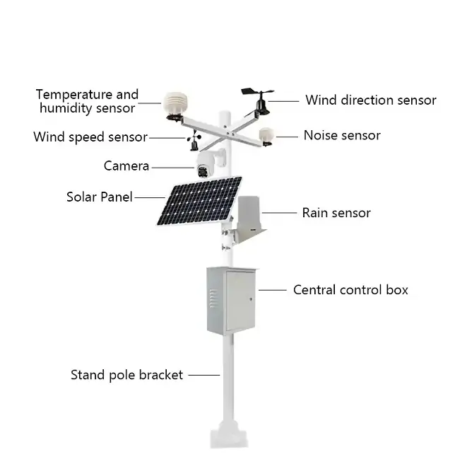
Integrated with comprehensive weather stations, these devices record visibility data to support power plant operations, maintenance, and environmental assessments.
Visibility Sensor vs Transmissometer
Both visibility sensors and transmissometers are used to measure atmospheric visibility, but they employ different measurement methods and are designed for different monitoring requirements. Understanding their differences can help users select the most suitable solution for weather monitoring, aviation, transportation, or industrial applications.
| 기능 | 가시성 센서 | Transmissometer |
|---|---|---|
| 측정 원리 | Forward light scattering | Light extinction over a fixed path |
| 설치 | Single-unit design | Separate transmitter and receiver |
| 설치 난이도 | Easy | Complex |
| 유지보수 요건 | 낮음 | 더 높음 |
| 비용 | Lower | 더 높음 |
| 전력 소비량 | 낮음 | 더 높음 |
| 측정 정확도 | 높음 | 매우 높음 |
| 대표적인 적용 분야 | Weather stations, highways, ports, industrial sites | Airports, aviation meteorology |
| 측정 범위 | Up to 20 km or more | Long-path visibility measurement |
가시성 센서
A visibility sensor measures atmospheric visibility by detecting light scattered by particles such as fog, haze, dust, and smoke. Its compact design, simple installation, and low maintenance requirements make it the preferred choice for most weather monitoring stations, transportation systems, and industrial monitoring projects. Modern forward scatter visibility sensors provide accurate real-time visibility data while keeping installation and operating costs relatively low.
Transmissometer
A transmissometer determines visibility by measuring the reduction in light intensity between a transmitter and a receiver placed a fixed distance apart. Because it directly measures atmospheric extinction over a longer optical path, it is often considered the reference technology for high-precision visibility measurement. However, transmissometers require more installation space, higher maintenance, and greater investment, making them most common in airports and aviation weather observation systems.
Which One Should You Choose?
For most applications, including weather stations, highways, ports, smart transportation systems, and industrial facilities, a visibility sensor offers an excellent balance of accuracy, cost-effectiveness, and ease of deployment. If your project requires the highest level of visibility measurement accuracy for critical aviation operations and complies with strict airport standards, a transmissometer may be the more suitable option. The best choice ultimately depends on your measurement range, accuracy requirements, installation environment, and budget.
How to Choose the Right Visibility Sensor
- For the vast majority of operational and automated monitoring needs (such as at airports, on highways, and at weather stations), forward-scattering visibility meters are the preferred and most widely used solution due to their overall advantages in terms of accuracy, reliability, ease of installation and maintenance, and cost.
- When data must meet the highest accuracy requirements for legal or scientific purposes, transmissive visibility meters should be selected.
- In situations involving mobile applications or where installation space is extremely limited, backward-scattering visibility detectors may be considered.
- Lidar and video-based systems are used for specific high-end remote sensing or visualization support needs.
When making a selection, measurement requirements, environmental conditions, budget, and maintenance capabilities must be taken into comprehensive consideration.
Future Trends in Visibility Monitoring Technology
Visibility monitoring technology is moving toward smarter, more connected, and more efficient systems driven by IoT, AI, and advanced optical sensing. The main trends focus on real-time connectivity, higher accuracy, lower maintenance, and multi-parameter environmental integration.
IoT-Enabled Visibility Monitoring
Visibility sensors are increasingly connected to IoT platforms for real-time remote data monitoring and centralized system management.
AI-Driven Data Analysis
Artificial intelligence helps analyze visibility patterns and improve forecasting of fog, haze, and low-visibility events.
Wireless and Low-Power Designs
Future sensors focus on wireless communication and ultra-low power consumption for flexible deployment in remote areas.
멀티 파라미터 통합
Visibility systems are combining multiple environmental measurements such as humidity, PM2.5, wind, and temperature for more complete data.
Higher Accuracy & Self-Calibration
New sensor technologies improve long-term stability through automatic calibration and reduced environmental interference.
Smart Transportation Integration
Visibility data is being integrated into intelligent transportation and aviation systems to support safer, automated operations.
Edge Computing Applications
Edge processing enables faster local data analysis, reducing latency and improving response in critical monitoring scenarios.

결론
Visibility sensors play a critical role in modern environmental monitoring by providing real-time, accurate data on atmospheric visibility under different weather conditions. From highways and airports to ports and industrial sites, they help improve operational safety, reduce weather-related risks, and support more efficient decision-making.
With continuous advancements in IoT connectivity, AI-driven analysis, multi-parameter integration, and self-calibration technology, visibility monitoring systems are becoming more intelligent, reliable, and easier to deploy. As industries move toward smarter infrastructure and automated operations, visibility sensors will remain a key component in ensuring safety and situational awareness across transportation, meteorology, and industrial applications.
어떤 옵션이 프로젝트에 적합한지 잘 모르겠다면 다음 주소에서 엔지니어와 직접 상담하는 것이 좋습니다. 옌타이 센서. In real applications, a short discussion about your system setup can usually save a lot of time and avoid costly selection mistakes later